Multi-level Adaptive Remote Sensing System (Completed)
About the MARSS Project
![]() Project Title: Multi-level Adaptive Remote Sensing System
Project Title: Multi-level Adaptive Remote Sensing System
Sponsoring Organization: USDOT Research and Innovative Technology Administration (RITA)
Program Manager: Mr. Caesar Singh
A joint research team of the Arizona State University and The University of Iowa, in collaboration with the Arizona Department of Transportation, the Iowa Department of Transportation, and the Maricopa County Department of Transportation, has been awarded a research project by the US Department of Transportation’s Research and Innovative Technology Administration, under The Commercial Remote Sensing and Spatial Information (CRS&SI) Technologies program.
Recent efforts initiated through funding by the RITA CRS&SI technology program have focussed on civil infrastructures such as bridges. Underwater monitoring technology, which is a necessary element for bridge scour evaluation needs to be developed for a robust total bridge health management. A Multilevel Adaptive Remote Sensing System (MARSS) is being developed to address the issue of underwater scour. The MARSS features a number of novel concepts such as comprehensive scour assessment under both clear-water and live-bed conditions, Residual Useful Life (RUL) estimation based on the current state, semi-autonomous Decision Support System (DSS) tools capable of fusing data from different sources to an immersive visualization environment, enabling decision making.
This project will give a potential solution to the RITA CRS&SI technology program’s motto to “reduce inefficiencies, improve system performance, and assess infrastructure condition through implementation of applied research.”
“The views and opinions expressed herein are entirely those of the author and do not represent the views of the Commercial Remote Sensing & Spatial Information Technologies Program, the U.S. Department of Transportation, or any of its Operating Administrations.”
- Public Abstract
- Background
- Need for RITA funding
- Novelty of the project
- Objectives
- Project Schedule
- Tasks & Deliverables
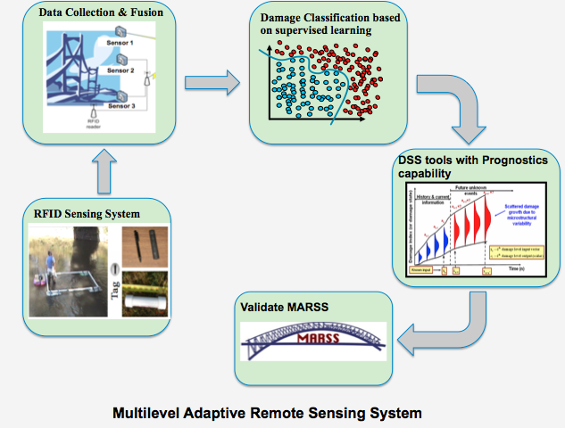 This program aims at significantly advancing the ability to develop smarter, more efficient and more reliable commercial remote sensing and spatial information (CRS&SI) technology products applicable to bridge scour monitoring. A multi-level adaptive remote sensing system (MARSS) is being developed; the framework integrates remote sensing and wireless technology for scour monitoring, adaptive information processing, prognosis and decision support systems (DSS) to provide valuable scour data, which is currently unavailable. Features from sensors and Radio Frequency IDentification (RFID) are combined to obtain three-dimensional (3D) information about scour, necessary for detection and prognosis of structurally deficient bridges. The adaptive detection approaches provide continuous and near real-time monitoring capability, while the improved DSS significantly reduces the amount of data required for processing by DOT personnel. These features make MARSS not only robust and applicable to different scour modes (clear-water and live-bed scour) and environmental conditions, but also cost effective. The proposed framework is expected to provide quantitative scour data, monitor scour state and mode, and estimate remaining useful life.
 Scour has been widely recognized as one of the main causes of bridge damage and failure, leading to significant direct and indirect costs and, in extreme cases, the loss of human lives. In the U.S. there are about 3,000 major interstate highway bridges that have been deemed structurally deficient due to scour-triggered deterioration and other damage. The scouring effect of flowing water around bridge piers and abutments is a common issue that engineers have to face both at the design and maintenance stages. Accurate estimation of equilibrium depths of scour and the time-dependent progression of the scour hole for clear-water and live-bed scour conditions is vital to preventing service life reduction and failures. The design of most bridges is mainly based on small-scale laboratory experiments and does not consider the complexities of natural river conditions such as unsteadiness in flow, presence of violent horseshoe vortices, and remixing of sediment. Predictions based on current scour methods do not always produce good results for the maximum scour depth in field conditions, and more important, do not provide unique 3D geospatial measurements of the scour hole volume. Minimizing future bridge damage due to scour and ensuring public safety requires the development and implementation of improved methods for reliable prediction of the time progression of the scour hole.The use of SHM (Structural Health Monitoring) techniques to detect damage or degradation is being pursued in many infrastructure applications. A SHM system must have the ability to collect, validate and make accessible, operational data on the basis of which decisions related to service-life management can be made. Our proposed MARSS (Multi Level Adaptive Remote Sensing System) addresses these challenges through an integrated approach comprising remote sensing technologies, data management, methodologies for reliability and life estimation and a DSS (Decision Support System) to forecast possible scour related damage and problems.
 The evolution process of scour around bridge piers and abutments is quite complicated and continuous in time which makes the development of a physically-based methodology for predicting bridge scour difficult. The available semi-theoretical approaches are largely based on the results of laboratory flume experiments on uniform non-cohesive bed materials. Therefore, their predictions in practice can be significantly different from direct field observations. We are unable to predict scour depth and volume around hydraulic structures in rivers, such as bridge piers and abutments, better than an order of magnitude. At present, traditional scour monitoring is a cumbersome task for DOT monitoring crews due to three main reasons:

Optimal selection of sensors for a particular body of water and bridge can save resources and improve the accuracy of scour data. This will lead to earlier detection of problems, allowing for the timely closure and remediation of scour-critical bridges, potentially saving lives. Therefore there is an imperative need for developing real-time reliable and robust systems for scour monitoring.The size and complexity associated with the challenges of automated monitoring and prediction of bridge scour requires a broad multidisciplinary effort. This is a “must” for any potential solution to be developed, adopted and later implemented. The RITA CRS&SI technologies program is asking for potential solutions to “reduce inefficiencies, improve system performance, and assess infrastructure condition through implementation of applied research.” This project brings together a group of experts with complementary capabilities. Without RITA funding, the extensive collaboration between these experts, which represents the essence of this project, is unlikely.
Current techniques proposed for scour monitoring are limited to foundational scour and mostly restricted to clear water scour. Currently there is no comprehensive study associated with the application of different remote sensing technologies for evaluating the safety and serviceability of an existing bridge for clear-water or live-bed scour. The proposed Multilevel Adaptive Remote Sensing System (MARSS), based on integrated remote sensing technologies, allows us to monitor the entire bridge for scour without being significantly affected by the environmental conditions. MARSS comprises of key elements in remote sensing, detection, information management, and prognosis to address the current technological barriers associated with scour detection, inspection and monitoring.
The novelties of MARSS are:

We utilize state-of-the-art low frequency RFID wireless sensors that facilitate automated, real-time, 3D geospatial measurements of the scour hole evolution, from its inception to an equilibrium stage. Our RFID scour assessment includes three complementary approaches: “folding chain,” “signal strength” and Lagrangian “geospatial” for both clear-water and live-bed scour mechanisms. The “folding chain” and “signal strength” approaches are unique because they allow measurements of scour depth when significant erosion of the river bed occurs, which is typical for live-bed scour conditions under high flows.
Another novelty of our RFID sensing is the ability of producing 3D mapping of the scour hole which is very difficult to obtain with traditional inspection methods. We use the Lagrangian “geospatial” approach where about 3,000 transponders/tags (equipped with the anti-collision RFID signal feature) can be detected simultaneously to map the size of the scour hole and develop a 3D contour map of its volumetric evolution. Our approach incorporates the anticollision RFID capability, which facilitates multiple readings and detection of tags at the scale of thousands.
A distinct benefit of our MARSS package is that it is cost effective for immediate adoption by the bridge engineering community. The user-friendly DSS tools integrate global and local data to not only provide more accurate monitoring information to the bridge owners, but also information on estimated useful life. Machine learning based data processing and classification techniques are implemented to screen stored data for indications of threshold scour conditions. In addition, for the first time established and easy to use pattern classification algorithms, as an integral part of the DSS, are used to search for statistical anomalies in the sensor data collected and perform QA/QC.
The remote sensing data is streamed to a centralized data repository via a cellular modem (3G). Once the data is aggregated in a single server, detection algorithms based on a pattern classification approach are implemented. Due to the stochastic nature of flow and scour processes in rivers, a probabilistic, data-driven prognosis methodology, which can effectively account for uncertainties due to environmental conditions, is used to predict the time progression of the scour hole for a wide range of flow and sediment bed conditions and the likelihood that critical scour event will occur. These tools allow the utilization of MARSS at sites exhibiting similar flow and riverbed characteristics.
The risk of structural damage to bridges resulting from river flooding and associated scouring requires immediate attention and constitutes the central objective of this project. To address this need, our vision is to develop and implement the Multilevel Adaptive Remote Sensing System(MARSS), comprising of different remote sensing, damage detection/prognosis techniques and Decision Support System (DSS) tools to perform continuous and near real-time bridge health management for different magnitude flow and scour.
The project goals are:


Task 1: Integrated sensing technology for scour monitoring
 Subtasks:

- Customization of the RFID system
- Information on the sensors
- Customization of RFID sensor
- Chain system
- Technology transfer for RFID
- Pre-processing for data analysis
- Scour depth & water discharge relationship
- Scour & particle movement
Outputs/Deliverables:
- Construct an outdoor RFID system consisting of antenna, transponders, reader, and communication technology capable of signal strength measurements for thousands of smart particles
- Describe the components of the RFID system that are mobilized from site to site if needed and those that are fixed. Develop a cost estimate for each component
- Provide technical information about the strengths and limitations of a field RFID system to monitor in-situ bridge pier scour
- Construct a scour chain system for measuring scour depth
- Provide guidelines on the installation and use of the RFID system and data analysis
- Refine a LabView-based computer code to conduct simultaneous, multiple readouts of smart particles under different flow conditions. The code will provide the smart particle ID and x,y,z coordinates with a user-friendly windows interface
- Provide continuous water discharge–sediment scour relations at the test sites over a range of flows including episodic and high magnitude events
- Develop enhanced knowledge of particle movement during scour
Task 2: Data Processing
 Subtasks:

- Requirements analysis
- Communication scheme
- Data muling
- Data Mining
- Data processing & storage
Outputs/Deliverables:
- A requirements analysis document describing the hardware, storage, power and requirements of the common data collection and processing
- A report on the configuration setup of the sensors stand-point on how to do data reporting
- A report with software source code attachment on how data muling is detected and implemented
- Scalable data selection algorithm for heterogeneous data sources for scour
- A report accompanied with software source code and SQL code on how the processing and database storage is organized
Task 3: Diagnosis and prognosis for life estimation
 Subtasks:

- Develop one-class Support Vector Machine (SVM) algorithm to classify RFID signals
- Evaluate SVM classifier sensitivity for clear-water and live-bed conditions
- Train the SVM algorithm using available data from field tests in Iowa
- Examine accuracy of the diagnostic algorithm using with field test in Arizona
- Implement the diagnostic algorithm in MARSS
- Develop Bayesian based Gaussian Process algorithm for the prediction of scour
- Train the prognosis algorithm using available field and laboratory data
- Examine the influence of clear-water and live-bed scour on the algorithm
- Validate the trained algorithm with the data from field tests in Arizona and Iowa
Outputs/Deliverables:
- A stand-alone software module for one-class SVM customized for bridge scour
- A stand-alone software module for stochastic prognosis model customized for time progression scour
- Guidelines for determining the current status of scour compared to its previous state
- Guidelines to estimate scour evolution which will include both supervised and unsupervised techniques
Task 4: Decision support system
 Subtasks:

- Accounts and access levels
- Historical data visualization
- Live data visualization
- Integration of diagnosis tools into the DSS
- Integration of prognosis tools into the DSS
- Bridge scour status tools into the DSS
Outputs/Deliverables:
- Report accompanied with software or video demonstration of the graphical user interface
- Report accompanied with software on how the security is implemented in DSS
- Report accompanied with software components of DSS on historical data visualization from the data storage
- Report accompanied with software components of DSS on live data stream visualization for in-situ viewing
- Report and software of integration of the diagnosis algorithms into the DSS
- Report and software of integration of the prognosis algorithms into the DSS
- Report and software of integration of the bridge scour status functions/algorithms into the DSS for scalability of bridge scour status
Task 5: Cost-benefit analysis & Outreach

Cost-benefit Analysis
Subtasks:
- Financial & risk analysis
Outputs/Deliverables:
- Financial data about direct/indirect costs & direct/indirect benefits involved in the adoption of MARSS as compared against the current practice
- Detailed Information collected from state DOTs on current inspection methods
- Technical benefit/ risk analysis results of multiple technical options & analysis about what is the best strategy for updating current practice using MARSS
Outreach
Subtasks:
- Reports & Publications
- Technology transfer MARSS
- Computer animation module
- Public information
Outputs/Deliverables:
- Including quarterly status reports, RITA special reports and fact sheets , minutes from advisory board meetings and final project report
- Metrics for measuring MARSS performances
- Results of the field tests
- Conference articles, peer-reviewed journal papers (manuscripts), and press releases
- Incorporating MARSS into DOT standards and protocols for bridge monitoring
- Raise public awareness of bridge safety
- Present a demo of MARSS
Outreach
First Field Test (03/09/13)
N Bush Highway Bridge,
Blue Point Picnic Area, Maricopa County, AZ
RFID Demo
Dr. Papanicolaou,University of Iowa
Team
Adaptive intelligent Materials and Systems Center
The University of Iowa
United States Department of Transportation
Arizona Department of Transportation
City of Tempe
Iowa Department of Transportation
Maricopa County Department of Transportation
Flood Control District of Maricopa County
Washington State Department of Transportation
Faculty
Aditi Chattopadhyay
AIMS Center Director
Regents’ Professor
Ira A. Fulton Professor of Mechanical and Aerospace Engineering
School for Engineering of Matter, Transport and Energy
Arizona State University, Tempe-AZ
Masoud Yekani Fard
Research Assistant Professor
School for Engineering of Matter, Transport and Energy
Arizona State University, Tempe-AZ
Sandeep Gupta
Professor & Chair, Computer Engineering
School for Computing, Informatics and Decision Systems Engineering
Arizona State University, Tempe, AZ
Thanos Papanicolaou
Donald E. Bently Faculty Fellow of Engineering
Department of Civil & Environmental Engineering
The University of Iowa, Iowa City, IA
Georgios Varsamopoulos
Research Assistant Professor
School for Computing, Informatics and Decision Systems Engineering
Arizona State University, Tempe, AZ
Christopher G. Wilson
Assistant Research Scientist
IIHR – Hydroscience and Engineering
The University of Iowa, Iowa City, IA
Students
Inho Kim
PhD Student
School for Engineering of Matter, Transport and Energy
Arizona State University, Tempe, AZ
Rajesh Kumar Neerukatti
PhD Student
School for Engineering of Matter, Transport and Energy
Arizona State University, Tempe, AZ
Sayan Kole
PhD Student
School for Computing, Informatics and Decision Systems Engineering
Arizona State University, Tempe, AZ
Joydeep Banerjee
PhD Student
School for Computing, Informatics and Decision Systems Engineering
Arizona State University, Tempe, AZ
Iordanis Moustakidis
PhD Student
Department of Civil & Environmental Engineering
The University of Iowa, Iowa City, IA
Joseph Milazzo
Master’s Student
School for Computing, Informatics and Decision Systems Engineering
Arizona State University, Tempe, AZ
United States Department of Transportation
Mr. Frank Jalinoos
Mr. Kornel Kerneyi
Arizona Department of Transportation
Dr. Anne Ellis
Dr. Itty P. Itty
City of Tempe
Mr. Chris Kabala
Flood Control District of Maricopa County
Mr. Amir Motamedi
Dr. Bing Zhao
Iowa Department of Transportation
Mr. David Claman
Maricopa County Department of Transportation
Ms. Kristina Larosa
Washington State Department of Transportation
Dr. Casey Kramer
Conferences
SPIE Smart Structures/NDE 2013
10-14 March, 2013
Town and Country Resort and Convention Center, San Diego, CA, USA
SPIE 2013 Paper: Prediction of scour depth around bridge piers using Gaussian process